The West Ham Park Low Traffic Neighbourhood has been a huge success. Traffic’s down—both inside the LTN, and on the boundary roads, where traffic flows well.
The new LTN has meant:
Traffic inside the LTN is down 46%
Traffic on boundary roads (Romford Rd, Portway, Upton Ln, and Vicarage Rd) is down 3%
Cleaner air to breathe
More people feeling safe walking and cycling on their own street
Sadly, there is a concerted campaign to get the LTN removed and allow heavy traffic back onto the streets around West Ham Park. The decision to make the LTN permanent has been “called in,” and will be scrutinised at a council meeting on Tuesday, 20th January.
We think taking out the LTN would:
make traffic worse and extend journey times, including for car drivers and bus users—because traffic on the main roads, including the important bus routes, will be interrupted by people cutting in and out of side streets not designed for that purpose
increase pollution, making it harder to breathe and making health problems like asthma worse
make our streets more dangerous, especially for children and older people
make it harder for local people to walk and cycle, especially people who don’t have access to a car or can’t drive
How can I help?
Tell your Councillors that you want the LTN to stay, especially if you live there, or if you travel into or through it—or maybe if your kids go to school there. Find out who your councillors are here.
Come along to the scrutiny committee meeting. It’s on Tuesday, 20th January, 6pm, East Ham Town Hall.Find out more here.
Please contact newham@lcc.org.uk if you plan to come to support the LTN and we can co-ordinate.
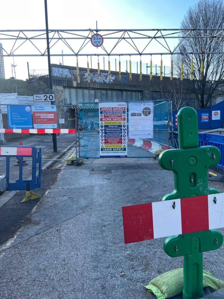
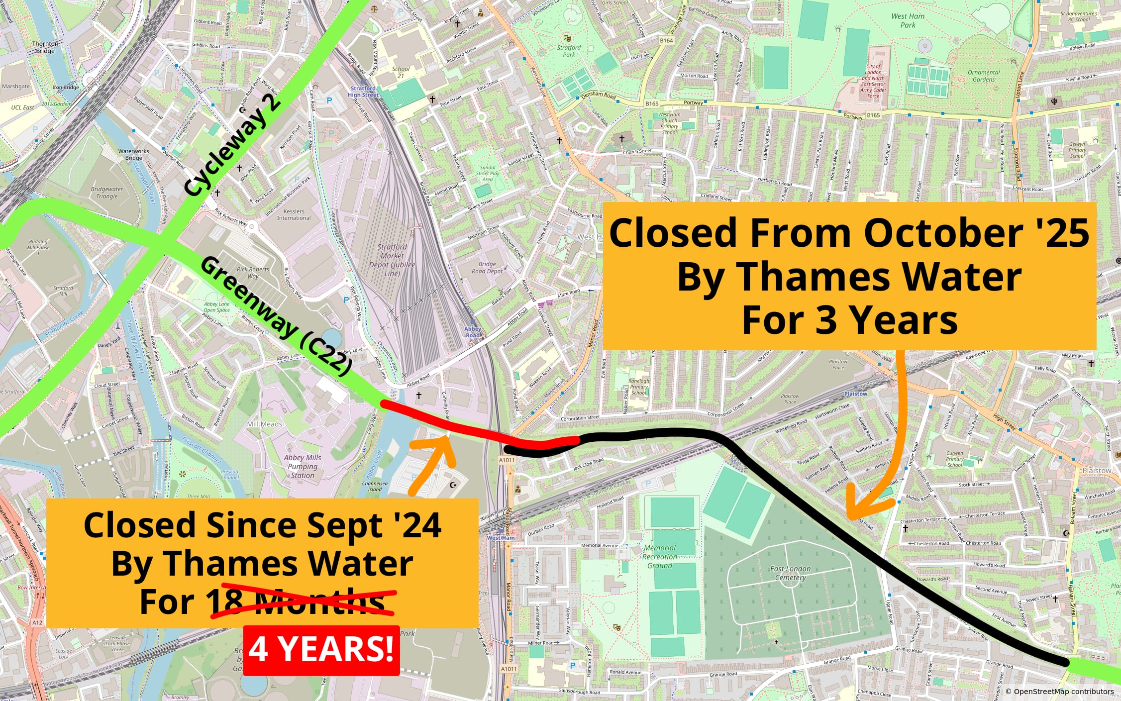
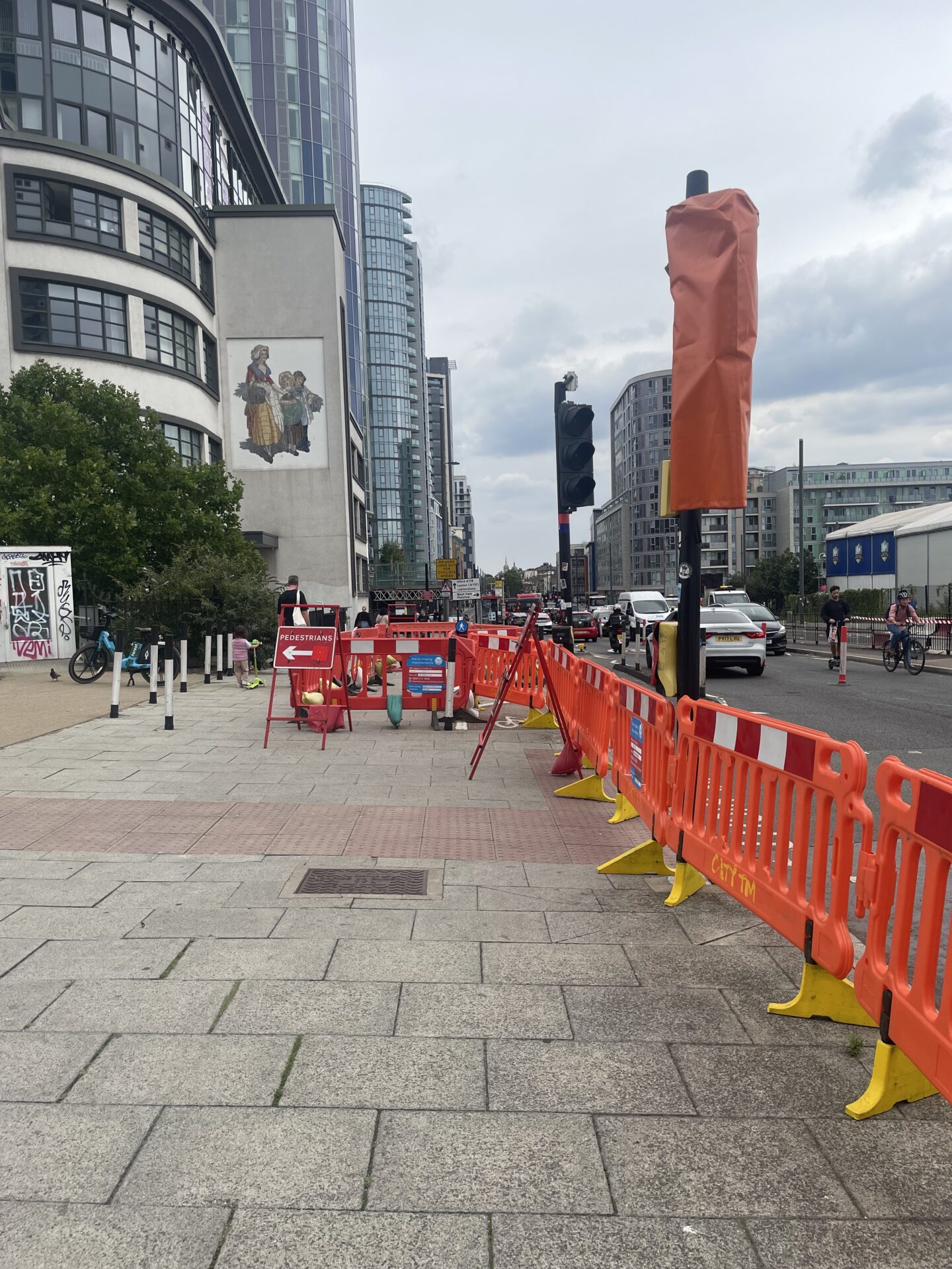
Thames Water have announced that their closure of the Greenway will extend to Upper Road from 26th January 2026. This closure will last for 3 YEARS.
We have repeatedly asked Thames Water to delay this closure until there is a safe diversion for the newly-closed section of the Greenway. They have refused to do so.
As detailed on our Greenway: Flushed Away! campaign page, the Greenway has now been closed for 478 days – with no end in sight for the 3000+ people who used the Greenway every day before the northern section was closed.
NB: The section marked “Closed from October ’25” is now programmed to be closed from 26 January 2026 onwards.
Schoolchildren, NHS workers, and families are put in danger every day. We are aware of at least 4 injuries on the diversion. More are inevitable if Thames Water presses ahead with this closure before a safe diversion is in place.
We have also heard stories on our “Map of Pain” of people having to pay significantly more to travel, people feeling they have to buy a car to travel short distances, and one family who’s moved out of Newham at least in part thanks to Thames Water’s works.
Our demands as part of our FLUSHED AWAY campaign remain as before:
Thames Water must not close any more of the Greenway until there’s a safe alternative for cycling. No dismounting, no riding in heavy traffic.
Thames Water must contribute financially to these safe diversions. Signs and speed cushions aren’t enough
Thames Water must pay to reinstate the Greenway to the highest quality when their works are done
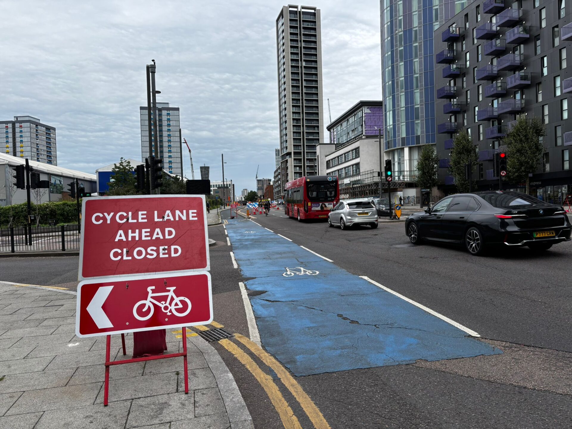
Thames Water’s new phase of sewer works have closed more of Newham’s protected cycleways. This is part of a worrying pattern of poor planning and hostile design that has plagued these works over the last 12 months. This is unacceptable and dangerous.
The current layouts at Stratford High Street. Images by Kerena Fussell and Karen Flanagan
We wrote to Thames Water on Tuesday 29th July 2025 to demand:
They fix the dangerous closure of Cycleway 2 before schools return in September
They delay the next phase of their works until there’s an acceptable diversion—which Thames Water should help fund
When they are finished, they fund the restoration and improvement of the closed sections of the Greenway to the highest quality.
(To the Thames Water project manager)
The next phase of Northern Outfall Sewer works on Stratford High Street has begun, and have resulted in you closing both a key pedestrian/cycle crossing and a large section of the protected TfL Cycleway 2. People cycling westbound are expected to ride in the road in front of heavy traffic, including lorries.
This layout is unacceptable. It’s dangerous for people cycling, particularly children and families. We are particularly concerned if this will be the state of affairs in September when children return to school.
Separately, you have confirmed on your website that you intend to close the Manor Road to Upper Road section of the Greenway from October onwards. The two months between now and October does not give Newham Council and other stakeholders enough time to provide a safe alternative route. The diversion routes you have proposed on your website even for the current closed section, including Rick Roberts Way and Abbey Road, are unacceptably dangerous, as they have remained since the Greenway initially closed on 11 September last year. The “safer” alternative you suggest, via Bridge Road, has still not been signed after 9 months.
The total length of your “temporary” closure of the Greenway will now be at least 4 years. We feel this results from Thames Water failing to properly monitor the condition of the NOS, and not understanding the importance to the community of its long-standing role as a key transport corridor for those using the cheapest modes.
Our position on this matter is simple:
Thames Water MUST, working with Newham Council, provide a safe way for people cycling on TfL Cycleway 2 to complete their journey, without dismounting or riding with heavy traffic. We expect this to be resolved, at latest, by the start of September when children return to school—irrespective of whether or not the works on High Street are complete by then.
Thames Water MUST NOT extend the closure of the Greenway until there is a safe, best-practice diversion for people walking and cycling. You must delay the next phase of your works until there’s a practical, usable alternative that does not involve cyclists dismounting, riding on narrow pavements, or riding in heavy traffic. We feel Thames Water should contribute financially to Newham Council’s costs in providing this diversion—piecemeal funds for ineffective speed humps and temporary signs, as we’ve seen on Abbey Road, are not enough.
Thames Water must, upon completion of your works, fund the restoration and improvement of the Greenway to the highest quality. This should be to the latest best-practice standards, and led by Newham Council.
We look forward to your timely response on this important issue for the local community.
On Monday 14th July at 7pm, we held a vigil at Centre Road/Woodford Road, where, on 16th June, Barry Shonibare, who lived locally in Forest Gate, was hit by a car driver—he died in hospital 5 days later. We were joined by many of Barry’s family and friends, some of whom had travelled to be with us. Our deputy co-ordinator, Karen, read the following remarks. We then held a minute’s silence and laid flowers at Centre Road car park, near the site of the crash.
Our deepest condolences go to Barry’s friends and family, who are here tonight.
Those of us who live here and travel through this stretch of Centre Road and Woodford Road on a regular basis know that it is dangerous. The relative safety of the wand-protected cycle lanes further up the road disappears. The road widens. As you can tell even now, speeding is endemic here.
We and our LCC colleagues in Redbridge have campaigned on this for some time. Surely now is the time to fund and build the measures that we know will prevent tragedies like this from happening again? We should not have to wait for someone else to be killed or injured before this danger is removed. As Barry’s family have stated, “no family or individuals should suffer this heartbreak again.”
We’ll now observe a minute’s silence to reflect, and to pay our respects to Barry Shonibare.
Newham Cyclists is deeply saddened to hear of the death of Barry Shonibare while he was cycling on the A114 Centre Road/Woodford Road. Our thoughts are with Mr Shonibare’s loved ones as they navigate an appalling loss that no family should ever have to endure.
People are exposed to danger every day on Centre Road/Woodford Road—with no protected space for cycling on the Newham part of the road, wide lanes and a painted median that invite speeding, and poor driver compliance at the zebra crossing at Capel Road. We completely concur with Mr Shonibare’s family in their call for speed cameras on Centre Road, and also urge the Mayor of London, TfL, and Newham and Redbridge Councils, to fund and deliver safe cycling infrastructure to ensure no-one else is killed or hurt on this important corridor.
Vigil
Newham Cyclists will be holding a short, low-key vigil to pay our respects to Mr Shonibare. We will be holding a minute’s silence.
Please feel free to bring flowers but be prepared to take them home with you. On account of the fire risk on Wanstead Flats, please don’t bring candles.
Our original statement follows:
We are deeply saddened to have received confirmation from the Met Police that the cyclist injured in a crash with a car on Centre Road in Wanstead Flats on Monday 16th June died in hospital five days later, on Saturday 21st June. He was 71 years old.
Our thoughts are with his loved ones, along with all those who witnessed and were involved in responding to the crash.
The Police have reported that the car driver, a 26-year-old man, stopped at the scene and1 has been helping them with their enquiries, and that no arrests have yet been made. They are asking for anyone with information such as dashcam or mobile footage to contact them on 101 quoting reference 3399/16JUN.
We are bitterly upset to be sharing news of another person killed while cycling in our borough at a place known by many of us to be dangerous, with high motor vehicle speeds and no protected cycling infrastructure. This gentleman’s death comes just over 5 months after the death of a man in his 20s at an unprotected junction on Stratford High Street.
Police Statement
For transparency’s sake, here is the Police statement received by our campaigning partners at the London Cycling Campaign on 02/07/2025:
Police were called at 12:22hrs on Monday, 16 June to reports of a collision between a car and a cyclist in Newham. Emergency services attended the scene at the junction of Centre Road and Capel Road where a cyclist had been severely injured. Despite the best efforts of medical staff, the cyclist – a 71-year-old man – sadly died in hospital on Saturday, 21 June. The family of the cyclist have been informed and are being supported by Family Liaison Officers. The driver, a 26-year-old man, stopped at the scene and has been helping police with their enquiries. No arrests have as yet been made. Enquiries are ongoing. Any witnesses or anyone with information, such as dash-cam or mobile phone footage, is asked to please call police on 101 quoting 3399/16JUN.
Although the Police initially reported that the driver stopped at scene, a later version of their statement said: “The driver – a 26-year-old man – who failed to stop at the scene but returned on foot, has been helping police with their enquiries.”↩︎
We have submitted evidence to the Bill Committee dealing with the Bus Services Bill (no. 2) which is currently making its way through Parliament. This legislation is generally about bus services outside London. However, a small number of campaigners opposed to protected cycling infrastructure have sought to add amendments which would ban bus stop bypasses across England, including in London. We felt it was important to highlight our view to the Committee.
We concur with the evidence submitted by our parent charity, the London Cycling Campaign.
We strongly oppose any clauses or amendments which would ban bus stop bypasses, also known as “floating” bus stops, which are a proven and safe solution to accommodate cycling and bus users on the same streets.
Most people will not cycle if they are expected to share space with high volumes of motor traffic—particularly buses. The differential in mass and kinetic energy between a person cycling and a bus is many orders of magnitude larger than that between a cyclist and a pedestrian. People do not need training or safety gear to “man up” on the road—they need fully separated, protected cycle tracks, which are the only way most people will feel comfortable cycling to destinations on main roads.
Bus stop bypasses, or “floating” bus stops, are a pragmatic solution to bus/bike conflicts. They reduce harm by eliminating dangerous crush movements between people cycling and buses pulling into the kerb at bus stops. They are established best practice in other European countries with dense, well-used bus networks, such as the Netherlands.
Newham was the site of some of the first BSBs in London, on Stratford High Street, installed in 2012/13.Even though they don’t meet modern best-practice standards and the ergonomics could be improved, these bypasses have proven successful at eliminating bus/cycle conflicts.
We can only find a report of one collision between a pedestrian and cyclist (pp. 14) at a BSB in Newham, at the Warton Road stop on Stratford High Street. This collision was categorised “slight,” i.e. not requiring hospital treatment. The BSBs are some of the safest parts of Stratford High Street for walking and cycling. By comparison, the stretches where the protected cycle track disappears (including unprotected cycle lanes and junctions, and a “traditional” unprotected bus stop in a lay-by) have a very poor safety record for both pedestrians and for cyclists.
More BSBs have since been built in Newham, in Stratford Town Centre, the Royal Docks, Westfield Avenue, and Romford Road. These examples have better sightlines and ergonomics to make it easier for cyclists and bus users to navigate the space. We are glad that Newham is one of several councils leading the way in safer bus stop design in Britain.
We acknowledge, and empathise with, Disabled bus users who find interactions with cycling intimidating—especially those with sensory impairments (including blind, low-vision, and d/Deaf people.) We understand why they may feel apprehensive at BSBs. Designers should ameliorate these issues by improving tactile guidance marking, colour contrast, level delineation, avoiding shared footways wherever possible, and removing obstacles and visual clutter to make it easy for cyclists to see (and give way to) bus users crossing to and from the island. This should go hand-in-hand with physical bus priority measures to deliver measurable, meaningful improvements to bus services, and education and behaviour change campaigns to improve compliance.
On the other hand, “traditional” unprotected bus stop designs—the “status quo” where buses and cycles are expected to dodge each other—present inherent problems for inclusivity. For those who may prefer to cycle slowly, or who experience fear about a collision with motor traffic—including less experienced cyclists, Disabled cyclists using cycles as a mobility aid, children, older people, and families—BSBs are the only way they can cycle on a street also served by a bus route in a relaxed way. We highlight from charity Wheels for Wellbeing’s briefing on BSBs: “Bus stop bypasses are presently an essential part of inclusive active travel networks that enable (pan-impairment) Disabled people to make journeys […] Banning bus stop bypasses would cause ongoing exclusion of Disabled people from active travel and bus use, and additional deaths/injuries in motor vehicle collisions.”
We note and highlight Dr Harrie Langton-Spencer’s 2024 paper “Disabled people’s access needs in transport decarbonisation” in IPPR Progressive Review, which highlights the need for collective placemaking and understanding the diversity of Disabled voices in resolving seemingly incompatible access frictions. Dr Langton-Spencer specifically highlights bus stop bypasses as an example. She writes: “Instead of striving for an unobtainable ‘fully accessible’, which obscures access frictions […] is a better outcome not one in which […] nobody is excluded and everybody has the best experience possible?”
A ban on “floating” bus stops would be a gross overreaction to a small risk, and be damaging to those who rely on cycling and buses.
A ban would make building fully protected cycle tracks impossible.
This would in turn make targets around sustainable transport, decarbonisation, and road danger reduction impossible.
A ban would disproportionately exclude inexperienced cyclists, children, older people, and Disabled people using cycles as mobility aids from cycling, pushing them back into expensive car ownership or needing to be driven around by someone else. This changes the character of cycling from a mode of transport to an extreme sport.
It would lead to an increase in bodged and disproven non-”solutions” such as shared pavements and 2-tier provision, which are less satisfactory—both for people cycling, and for Disabled pedestrians and bus users with sensory impairments.
A ban would frame interactions with cycling as more risky and dangerous to bus users than interactions with motor vehicles. Casualty data from STATS19 shows this is simply untrue.
We caution the Bill Committee of cherry-picked evidence used as a “gotcha” to support a claim that all “floating” bus stops are dangerous (for instance, video of a particularly busy stop in a tourist area where people unfamiliar with UK traffic rules regularly walk into the path of all kinds of traffic; or a photo of a legacy paint-on-the-pavement cycle lane that isn’t representative of modern standards.) One could do the same exercise with “traditional” unprotected bus stops, or for other street design features—such as advanced stop lines, or indeed many bus stations. The evidence on the efficacy and safety of BSBs must be taken as a whole, and compared to other options in the highways design toolkit—which have overwhelmingly failed to deliver positive outcomes for bus patronage and for the safety of people cycling.
We urge the Bill Committee to reject amendments that would ban bus stop bypasses.Other European countries show that BSBs are a key component of comprehensive, well-used, and inclusive bus networks that are fit for the future. England should follow their lead, and focus on measures to make buses better—rather than a logically incoherent ban on BSBs that would only serve to make cycling worse.
We strongly oppose any clauses or amendments which would ban bus stop bypasses, also known as “floating” bus stops, which are a proven and safe solution to accommodate cycling and bus users on the same streets.
This is our 2024/25 annual report and Statement of Financial Affairs. We approved it at our AGM on Monday 28th April. For ease of reading and searching, we have copied the text of the annual report to this page; you can download the PDF original, and the SoFA, at the foot of the page.
Summary
2024-2025 was a busy year for cycling in our borough.
There were a number of very positive developments in terms of new, high-quality infrastructure being opened and being built. The first completed sections of the long-fought for Romford Road cycle track officially opened. So has the first section of the Westfield Avenue cycleway, turning one of the worst streets in the borough for cycling (a dreadful “stroad” type design left over from the Olympics) to one of the best. The Royal Docks Corridor scheme from Canning Town to Pontoon Dock and London City Airport is nearing completion, and is truly great. We have also seen a number of public realm improvements and permanent mode filter upgrades, and the roll-out of the borough-wide 20mph limit. Work has also just begun on phase 1a of Cycle Future Route 7 from Leyton to Stratford Town Centre, which will improve one of the worst parts of Cycleway 16 and deliver a much-needed cycling connection over the Great Eastern Railway.
The new West Ham Park LTN, despite some opposition, appears to have settled in and is working well. This scheme in particular is a game changer, as Newham are delivering it simultaneously with the Romford Road works. This is the first time the Council has treated both side roads and main roads at the same time, providing a joined-up network of safer streets.
We are pleased that the ambition shown by portfolio holders and officers at Newham Council is generally high. We have seen some positive consultations for future schemes, for instance for the crossing of Water Lane on the Stratford-Forest Gate backstreet Cycleway link.
Unfortunately, there were also negative developments, particularly the sudden long-term closure of the Greenway, TfL Cycleway 22, by Thames Water in September 2024. At time of writing the Greenway at West Ham has now been unusable for 7 months, which has had a serious impact on children, families, and NHS workers at Newham Hospital who relied on it for their travel. We have had more contact about the Greenway than any other campaigning issue in the history of Newham Cyclists. Newham Council’s diversion is not fit for purpose, after somewhat nebulous fears about traffic displacement from the Police led to them abandoning their original plan to close Abbey Road E15 to general traffic. It is also now clear the “temporary” closure of the Greenway will be longer than the originally planned 18 months. We have also been monitoring the long-term closure of the ExCeL waterfront path on NCN route 13, which raises similar concerns about the cycle network’s dependence on permissive paths that private landowners can close at will.
Considerable disruption has arisen from works for the construction and mitigation of the Silvertown Tunnel, an urban motorway project that TfL has mortgaged £2.2bn of future tolls on. The desultory “cycle shuttle” (bike bus) is not an adequate mitigation, and has already proven in its first weeks to be inadequate for the demand to cross the river by cycle east of Tower Bridge.
A continued lack of action on legacy unprotected junctions has also been evident. Tragically, Newham saw its first cycling fatality in 4½ years in mid-January 2025, at a known dangerous junction on TfL Cycleway 2 on Stratford High Street. The person killed was a man in his 20s. This section of Cycleway 2 features 4 of the 6 most dangerous junctions on our list, and at each, the physical separation for cycling disappears. We have pushed the Council and TfL to stop accepting the “Cycleway” designation as a fait accompli, and to get on with treating the dangerous junctions in line with best practice standards. We are pleased that both Newham Council and TfL recognise the need for rapid action, but they must work together to deliver a meaningful, permanent scheme, speedily, and without being watered down, mired in endless rounds of traffic modelling, or punted out to the next political cycle.
On Monday 20th January at 6pm, we held a vigil at the site of a crash the week prior, which claimed the life of a cyclist in his 20s. Our co-ordinator, Jonathan, read the following prepared remarks. We then held a minute’s silence to commemorate the man who was killed.
We’re here tonight to mark the sad events of last Monday. Details are still scarce to us, and no doubt will become clearer in the coming weeks and months as the Police and coroner make their inquiries.
Right now, we have no further details about the person who died, nor the circumstances of the crash.
Fatal crashes involving lorries and people cycling are a distressingly regular occurrence. The last one in London that we know about was only 10 weeks earlier, on 2nd November last year, when a 27-year-old man was hit and killed in Putney while he was on his way to meet his friends for lunch.
Last week’s crash took place just a few feet away from here, at a junction that was, between 2019 and 2023, Newham’s fourth most dangerous for cycling. Despite being a known danger spot, Carpenters Road junction has been left largely untouched and unprotected for over a decade—just like its neighbours at Cooks Road and Warton Road. It should not take someone, or someones, losing their life for the responsible authorities to take action to remove danger from our streets—at a location that the thousands of us who navigate Stratford on a daily basis know all too well. Even one death is one too many.
Today we are here to acknowledge yet another violent and premature end to a person’s life on London’s roads—and to pay our respects to the unknown rider whose life ended here. And it is easy to forget when policymakers, journalists, and indeed campaigners like us, so readily reduce traffic fatalities to statistics, but let us remember: Every single death or serious injury in traffic is someone’s personal tragedy.
No matter who the young gentleman who died here was, no matter what he was doing, no matter where he was going: no-one deserves a sudden and violent death while simply going about their lives.
We’ll now observe a minute’s silence to reflect, and to pay our respects to the person who was killed.
We support this scheme and hope that it will go together with a wider scheme to improve both the C-link and the Water Lane area, which is blighted by high volumes of high speed traffic despite not being a main road. We are very aware that there was recently a fatal crash here (two Fridays ago.)
We’ve asked for clearer visual priority for people walking and cycling, with a continuous surface treatment, to make more likely that drivers will give way to people crossing (as they legally should.)
You can find our response below, and use that to inform your own response to the survey.
Inspired by Camden Cyclists’ excellent series of the same name, this post is about the progress of the many cycling infras schemes with spades in the ground in Newham. We will post new ones as and when volunteer time allows and there’s something new to report.
Romford Road
As a large project which will take a number of years, the long-awaited Romford Road public realm improvement scheme is broken up into sections. Sections B eastbound (Water Lane to Radlett Close) and D eastbound (Woodgrange Road to Richmond Road) were the first to be consulted on, and are the first to have been substantively finished. Snagging work should now have been completed for both.
Work has now begun on section B westbound. We’d expect work on section D westbound to take a little longer, owing to the recent fire at Forest Gate Police Station. Work continues on sections H and I.
The open cycle track on sections B and D eastbound is already being very well used by people cycling. In particular a lot of cyclists want to turn right into Dyson Road and the West Ham Park area, and so are already cycling around the barriers to use the zebra crossing.
The massive carriageway on the Westfield Avenue bridge (2 lanes + central hatching!) has already been narrowed by the arrival of materials presumably associated with the construction work. This, combined with hatching on the opposite side, reduces the road width to its final configuration of one traffic lane in each direction. This appears to have already led to a significant reduction in vehicle speeds at what was a real danger spot for people driving, and bodes well for improved safety on the whole corridor for all road users.
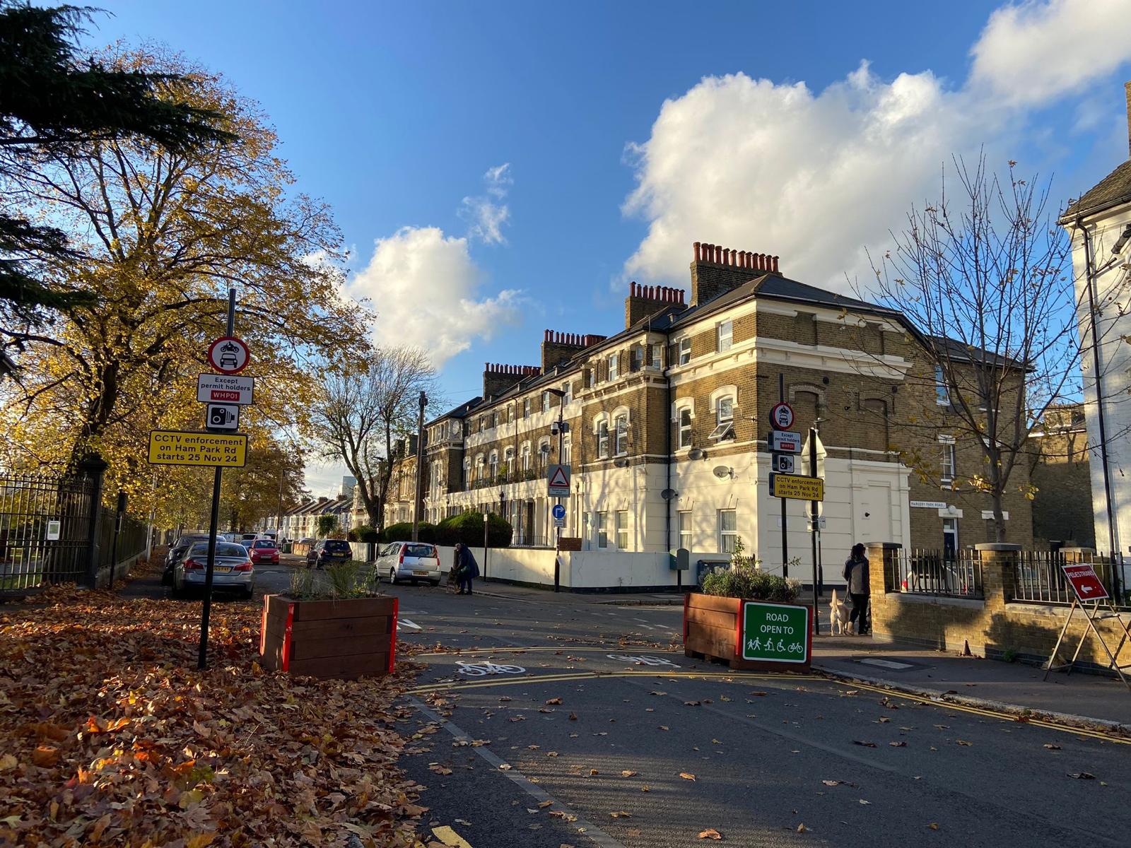
West Ham Park LTN
The planters have been installed at the point closures on Ham Park Road for this LTN which is going live on Monday 4th November, although the formal “no motor vehicles” signage has yet to be installed. Signage for the other two point closures on Vicarage Road and Tavistock Road will also need to be installed soon. (UPDATE 8 November: This was an error in the traffic order, the implementation date is now 25 November.)
You don’t need to stand on Ham Park Road long to see why this LTN is desperately needed! Even at 2pm on a Saturday when this photo was taken, large bursts of traffic were forcing their way through this narrow residential street from both the east and the west. We were somewhat concerned for the safety of a cat crossing the street (alas, not visible in the photo!) We look forward to this LTN coming into effect soon, for a safer West Ham Park for all cats (and humans.)
Greenway diversion
We are still waiting for the delivery of any measures at all to make the appalling Greenway diversion via Abbey Road safer. Our latest understanding is that speed cushions are imminent (a purchase order having supposedly been raised by Thames Water) and the ETMO to close Abbey Road to motor vehicles will be coming in late November (UPDATE: now cancelled because Newham Council chickened out) followed by permanent works to build out the south pavement to become a shared cycle track. We will post when we have more confirmed details. There is still no sign of permanent signage for the diversion, with portable temporary signage still in use and still regularly going missing.
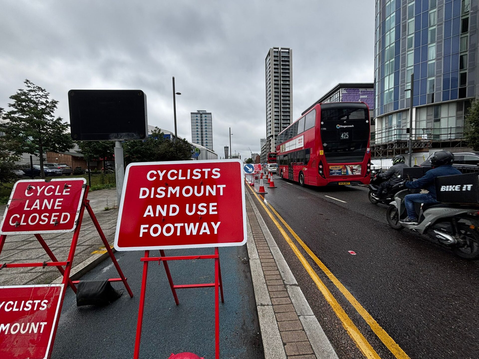
New “cyclists dismount” signage has appeared on the shared pavement under the bridge, which has been narrowed… by Thames Water’s own storage unit. “Cyclists dismount” signs are generally not helpful and should only be used as a last resort—they do little more than tell people cycling they’re unwelcome, and many people ignore them. They are also not inclusive of Disabled cyclists using cycles as mobility aids, who may not be able to easily dismount.
We feel this dismounted section can be avoided by extending the traffic light phase for the pedestrian crossing, sending cyclists on this phase through the section of carriageway under the bridge. This is eminently achievable, but requires Thames Water and Newham to collaborate on traffic light phasing, signage, and road markings that work.
Greenway users have now been exposed to over 6 weeks of unacceptable danger, all of which would have been avoided had Thames Water planned their works properly and not closed the Greenway until the diversion was kid-safe.
Work around Beckton station is continuing. The priority pedestrian and cycling crossing on the Frobisher Road arm of the roundabout (into the Asda car park) is now available for use. Drivers leaving the roundabout are generally respecting the priority of people walking and cycling here. It remains to be seen how this develops with time as the scheme nears completion and the volume of cyclists increases.
The connection with the Beckton Corridor route is closed for resurfacing. The traffic lights across the bus station are largely complete, although they’re not turned on yet. There’s an unusual detail of the cycle part of this crossing being separately marked as if it were a parallel crossing, although the traffic lights suggest a shared toucan crossing. The cycle part also uses non standard pedestrian “stud” markings, rather than the “elephants’ footprints” that are generally used in this country to mark a cycle crossing.
Royal Docks Corridor
This scheme is now well underway with work visible on site throughout the entire corridor from Canning Town to Connaught Roundabout. Kerblines have begun to appear on North Woolwich Road near Pontoon Dock, and the junctions are progressing nicely.
Extra work is now happening on the previously-opened eastbound cycle track near the Oasis Academy and petrol station at West Silvertown. The planting is generally in, although not looking as verdant as Romford Road just yet. Junctions south of the viaduct are still largely on temporary traffic lights.
Some value engineering is evident on the Silvertown Way viaduct, where the original plans for a fully stepped cycle track have been replaced by a semi-protected painted cycle lane with kerbs at intervals. The kerbed dividers seem sufficiently bulky that it seems unlikely people will be tempted to speed and risk crashing into them, but it remains to be seen whether drivers end up invading these lanes and parking in them.
Work on the northern end near Canning Town station and the connection with Cycleway 3 seems largely complete, albeit not including the more direct crossing of Cycleway 3 across Canning Town Roundabout which we suspect may come as part of a later scheme.
Tidal Basin Roundabout
Work appears largely complete at the new Tidal Basin Roundabout, although the new shared pedestrian and cycle crossings are still mostly closed off.
This scheme is primarily to accommodate the enormous volumes of traffic which are likely to use the new Silvertown Tunnel, an urban motorway project which wehaveconsistentlyopposed. Even with the new greenery, you only need to look at the wide, sweeping traffic lanes to see who the roundabout and tunnel are really designed for: heavy lorries, and large volumes of private cars. People walking and cycling will be expected to wait up to 5 times to cross this massive new incarnation of the roundabout, adding further delay and encouraging risk-taking on journeys to City Hall, Dock Road, and the proposed new housing at Thames Wharf.
It remains to be seen how this operates in practice. We remain deeply sceptical that the Silvertown Tunnel project will achieve its stated aims, and think it will be seen as an historic planning failure like the vestiges of the Ringway scheme from the 1960s. This roundabout, which expects those without a car to dance between traffic islands, is only part of that legacy.
Bow Roundabout
Work on this scheme has begun and will continue for some months. The usual “cycle gate” arrangement for Cycleway 2 at Bow Roundabout continues on temporary traffic lights.
The effect will be to add an additional traffic lane on one side of the roundabout, create an additional eastbound lane for traffic leaving the roundabout onto Stratford High Street, create an additional westbound lane for traffic entering the roundabout from High Street, reverse the direction of the connecting lane under the flyover, and cut back the contraflow lane so that uses this connection to join the main westbound carriageway to go around the roundabout.
TfL declined to assess the new layout under their Cycling Level of Service or Junction Assessment tools, because (cf. the FOI response) “the decision to separate cyclists from traffic at this location has already been established here and the route is a Cycleway.” We find this logic questionable:
The creation of additional lanes (and indeed this scheme being hurried through using the DCO before the Tunnel opens) suggests TfL believes traffic volumes will increase here.
CS2 eastbound is not physically separated from general traffic here. There is an existing issue where the painted lane is blocked by parked cars, forcing cyclists to merge into motor traffic that’s accelerating off the roundabout.
This issue will be compounded in the new layout by increased traffic volumes, the overwhelming majority of which will be through traffic, whose drivers may see the motorway-type design as an invitation to speed…
and by the new merge movement just west of Cooks Road, which runs the risk of drivers in the left-hand lane swerving into the cycle lane to avoid a collision with another vehicle merging from the right. While curtailing the contraflow lane is very welcome and will reduce the risk of motorists colliding head-on, we question why a new eastbound lane on High Street for the approx 60 yards before it merges into the first lane was considered necessary.
We will be monitoring this new layout very closely when it goes live, and won’t hesitate to hold TfL to account for any necessary mitigations to ensure the safety of people walking and cycling.
This is where 2 general traffic lanes off the roundabout will become 1—which may make the painted lane feel even more vulnerable than it currently is.
The new series of BBC1’s Ambulance was partly filmed at London Ambulance Service’s control room at Dockside earlier this year, and features locations and events many will recognise (including the fire at Forest Gate police station.)
The Romford Road cycle track’s new planting helped inspire a firefighter to rejuvenate Stratford Fire Station’s own garden space.He was interviewed recently on Gardeners’ Question Time on BBC Radio 4. We think the rain garden past the fire station makes it one of the loveliest cycle lanes in Newham.
Other news across London…
While Newham Cyclists focuses on Newham, your cycle knows no bounds and many of our journeys start and finish outside our borough. Here’s some news from our neighbours that may be of interest…
Hackney Cycling Campaign have done an extraordinary job pressuring Hackney Council over their unsafe Pembury Circus design (largely consisting of magic painted rectangles & early release traffic lights.) The decision has now been called in for review, and they are hoping to involve Active Travel England as the project uses Levelling Up Fund money. If you walk or cycle through Pembury or Hackney Central, get in touch with HCC to see how you can help them demand better from their council.
Redbridge Council have launched a draft of their Sustainable Transport Strategy.Contact our friends at Redbridge Cycling Campaign if you’re interested in helping them. Of particular interest to us is Ilford Garden junction, which will connect to the end of the Romford Road cycleway. Deadline 5th January.
Keeping track of the many ongoing projects in Newham is a lot of work for our committee and volunteers. If you live or work near one of these sites, we’d really appreciate it if you would volunteer to tell us when things make progress. Email newham@lcc.org.uk or join our discussion group if you can help us, or want to get involved in our campaigning.